
The UN Geospatial Strategy

25 May 2021
By Kyoung-Soo Eom, Chief of Geospatial Information Section, Technology Operations Service, Operations Support Division, OICT
Since the establishment of the United Nations, cartography and geospatial information have been an important component of the Organization. In 1948, the Committee of Experts on Cartography sought to answer two questions:
- What should the United Nations do to stimulate and assist Member States in the development of the mapping sciences?
- What sort of cartographic service did the United Nations need to carry out this program, for its own operations, and in its relations with the specialized agencies?
"The Geospatial Strategy for the United Nations aims to contribute to the data ecosystem by enabling location information for the Organization. The vision is to build synergy on activities and investments on geospatial information management in the United Nations, "Delivering as One" by bringing geospatial data to innovate and to act for a better world." — Mr. Patrick Carey, Acting Assistant Secretary-General, OICT |
To facilitate the development of the mapping sciences, over the past seven decades, the Organization has been using geospatial information to meet the UN’s diverse mandates and operational requirements.
Today, the United Nations Committee of Experts on Global Geospatial Information Management (UN-GGIM) is the apex intergovernmental mechanism for making joint decisions and setting directions regarding the production, availability and application of geospatial information within national, regional and global policy frameworks. Under the UN-GGIM framework, the United Nations Geospatial Network, a coalition of entities within the United Nations system that engages in geospatial information management activities, has come together to strengthen the coordination and coherence of geospatial information management within the United Nations system, including its overarching trends, technology, practices, data, needs, capacity building, and partnerships.
In parallel, with the latest organizational reform of the United Nations, the Secretary-General launched the Secretary-General’s Data Strategy, aiming to build a United Nations data ecosystem for “better decisions and stronger support to people and planet—in the moments that matter most”. As an integral part of the data ecosystem, geospatial information is critical to gaining insight to better understand events and phenomenon patterns, and to act upon them. In this regard, the United Nations Secretariat used this as an impetus to prepare a strategy focused on geospatial information to reflect the latest developments and needs within the Organization. To draft this strategy, there was a collaboration and consultation process amongst the geospatial experts and the user community within the Secretariat.
What is the Geospatial Strategy?
The Geospatial Strategy aims to set direction to support the implementation of the mandates of the United Nations Secretariat. The intent of the strategy is to design, foster and build synergies for activities and investments in geospatial information management in the United Nations Secretariat, in coordination with the wider geospatial and data community of the United Nations system “Delivering as One”.
The Geospatial Strategy envisions the effective, efficient and universal use of geospatial information in support of all mandates and operations of the United Nations for a better world as contained in its main pillars: Peace and Security, Human Rights, International Law, Sustainable Development, and Humanitarian Aid.
The mission of the Geospatial Strategy aims to mainstream the use of geospatial information across the UN system for unified, integrated and accessible information; analysis and visualization for evidence-based decision-making; and data action in support of peace and security, human rights, international law, development, and humanitarian aid.
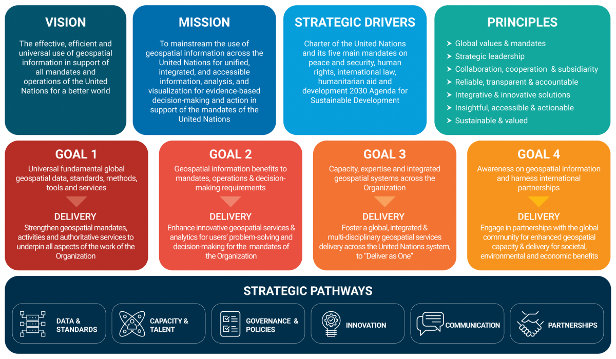

The Geospatial Strategy is comprised of 4 goals:
- Goal 1:
Strengthen geospatial mandates, activities and authoritative services to underpin all aspects of the work of the Organization. - Goal 2:
Enhance innovative geospatial services and analytics for users’ problem-solving and decision-making that support the mandates of the Organization. - Goal 3:
Foster a global integrated, federated and multi-disciplinary geospatial services delivery across the United Nations system "Delivering as One." - Goal 4:
Engage in partnerships with the global community for enhanced geospatial capacity and delivery for societal, environmental and economic benefits (including with Member States, non-governmental organizations, the private sector, innovators, academia, geospatial societies, and citizens).
Way Forward
To realize the Secretary-General’s Data Strategy, the geospatial community of the United Nations Secretariat will establish a “Geospatial Action Group”. This Group will include geospatial information experts and users from the Organization in order to achieve the following goals:
- Participate in the implementation of the wider Data Strategy and its governance mechanism, the Data Governance Council, to ensure interlinkages between the relevant data stakeholders in the Organization.
- Coordinate its action with the United Nations Geospatial Network and its strategic orientations and activities as described in the Blueprint.
- Elaborate a governance model on geospatial activities in the United Nations Secretariat
- Elaborate a Geospatial Action Plan to guide and build synergies between the activities in the United Nations Secretariat.
- Advise and coordinate programmes and projects involving geospatial data and information including in close coordination with the United Nations Data Action Group, geospatial information users and experts.
- Coordinate the implementation of the Geospatial Action Plan.
Leveraging geospatial data is critical to the development of a UN-wide data ecosystem designed to help our Organization better deliver on its mandates and serve communities around the world. As such, the Geospatial Strategy will be an important enabler of the UN Data Strategy.
Note: The views expressed herein are those of the author and do not necessarily reflect the views of the United Nations.